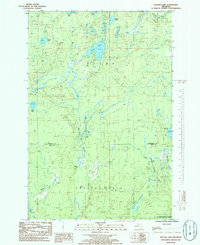
1985 Map of Nelson Lake
USGS Topo · Published 1986About this map
Fence Lake and the surrounding wilderness of the Copper Country State Forest dominate this mid-1980s landscape on the border of Baraga and Iron counties. The terrain is defined by a complex network of waterways, including the West Branch Michigamme River and the winding E Br Fence R. While largely undeveloped, the map documents specific points of human modification to the natural drainage, notably at Hamilton Dam and Nylegan Dam. A single Gravel Pit near the river indicates the localized industrial activity typical of the Upper Peninsula’s resource-heavy economy. Collectors of Michigan history can trace the primitive roads and pipelines that traverse this wooded region, connecting smaller water bodies like St Johns Lake and Nelson Lake through the dense forest sections of Crystal Falls and Spur.
Find a feature on this map
18 named features on this map. Tap any name to fly to it.
Don’t see what you’re looking for? This feature index may not catch every label — zoom into the map to look around manually.
Map Details
Editions of this 1985 Nelson Lake Map
This is the sole edition of this map. No revisions or reprints were ever made.
Other maps of this area

1895 · Ned Lake
USGS Topo · 1:62,500

1899 · Witbeck
USGS Topo · 1:62,500

1955 · Witch Lake
USGS Topo · 1:24,000

1955 · Ned Lake
USGS Topo · 1:62,500

1955 · Herman
USGS Topo · 1:62,500

1955 · Witch Lake NE
USGS Topo · 1:24,000

1955 · Witch Lake
USGS Topo · 1:62,500

1956 · Three Lakes
USGS Topo · 1:24,000

1956 · Michigamme
USGS Topo · 1:62,500

1956 · Michigamme
USGS Topo · 1:24,000