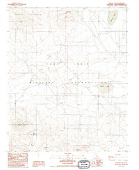
1986 Map of Nelson Lake
USGS Topo · Published 1986About this map
The Granite Mountains dominate the northern landscape of this Mojave Desert high country, where drainage patterns terminate in the distinct basins of McLean Lake and Nelson Lake. Much of the territory falls within the boundaries of the Fort Irwin Military Reservation, reflecting the region's mid-century shift toward large-scale federal land use. The sparse settlement of Pioneer sits in the southwestern portion of the map, while several technological landmarks such as Radio Towers, a dedicated Radio Facility Call 3986T, and a separate Radio Tower 4446T point to the area's importance for communications and defense monitoring. The terrain is defined by complex contouring around the peaks and the flat, silty beds of the lakes, illustrating a landscape where natural topography and modern military infrastructure converge.
Find a feature on this map
10 named features on this map. Tap any name to fly to it.
Don’t see what you’re looking for? This feature index may not catch every label — zoom into the map to look around manually.
Map Details
Editions of this 1986 Nelson Lake Map
This is the sole edition of this map. No revisions or reprints were ever made.
Other maps of this area

1933 · Avawatz Mountains
USGS Topo · 1:250,000

1947 · Trona
USGS Topo · 1:250,000

1948 · Trona
USGS Topo · 1:250,000

1948 · Quail Mountains
USGS Topo · 1:62,500

1948 · Leach Lake
USGS Topo · 1:62,500

1948 · Goldstone Lake
USGS Topo · 1:62,500

1948 · Tiefort Mountains
USGS Topo · 1:62,500

1951 · Goldstone Lake
USGS Topo · 1:62,500

1951 · Tiefort Mountains
USGS Topo · 1:62,500

1951 · Quail Mountains
USGS Topo · 1:62,500