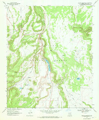
1969 Map of Nelson Reservoir
USGS Topo · Published 1972About this map
Nelson Reservoir sits at the heart of this Apache County landscape, fed by the waters of Nutrioso Creek as it winds through the Apache National Forest. This late-1960s survey documents a high-country environment managed for water storage and resource extraction, evidenced by a series of smaller impoundments including Trinity Reservoir, McKay Reservoir, and Glen Livet Reservoir. The presence of these named reservoirs suggests a sophisticated local water management system used for ranching or forestry during this period.
Find a feature on this map
30 named features on this map. Tap any name to fly to it.
Don’t see what you’re looking for? This feature index may not catch every label — zoom into the map to look around manually.
Map Details
Editions of this 1969 Nelson Reservoir Map
This is the sole edition of this map. No revisions or reprints were ever made.
Other maps of this area

1886 · St Johns
USGS Topo · 1:250,000

1892 · St Johns
USGS Topo · 1:250,000

1922 · Nutrioso
USGS Topo · 1:125,000

1954 · Clifton
USGS Topo · 1:250,000

1954 · Saint Johns
USGS Topo · 1:250,000

1957 · Clifton
USGS Topo · 1:250,000

1957 · Saint Johns
USGS Topo · 1:250,000

1958 · Clifton
USGS Topo · 1:250,000

1958 · Saint Johns
USGS Topo · 1:250,000

1958 · Alpine
USGS Topo · 1:62,500