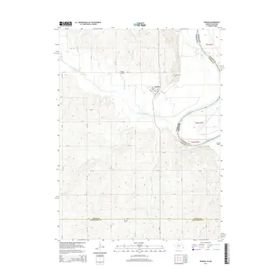
2014 Map of Nemaha
USGS Topo · Published 2014About this map
The Little Nemaha River and the Missouri River converge along the eastern edge of this landscape, defining the southeastern corner of Nemaha County where it meets Missouri and Richardson County. The village of Nemaha serves as the central hub, oriented along Nebraska Ave and Main St just west of the river valley. The topography is marked by a complex system of drainage runs and hollows, including Happy Hollow and the distinctive Whisky Run that cuts through the southern bluffs. Local genealogy is anchored by the Nemaha Cem on the town's outskirts and the Penniwell Cem to the south. The riparian environment is further detailed by features like Morgan Island in the Missouri River and several tributary streams such as Swartz Run and Jarvis Cr that drain the upland agricultural sections.
Find a feature on this map
48 named features on this map. Tap any name to fly to it.
Don’t see what you’re looking for? This feature index may not catch every label — zoom into the map to look around manually.
Map Details
Editions of this 2014 Nemaha Map
This is the sole edition of this map. No revisions or reprints were ever made.
Other maps of this area

1915 · Falls City
USGS Topo · 1:62,500

1915 · Nemaha
USGS Topo · 1:62,500

1915 · Howe
USGS Topo · 1:62,500

1916 · Humboldt
USGS Topo · 1:62,500

1939 · Nemaha
USGS Topo · 1:62,500

1949 · Nemaha
USGS Topo · 1:62,500

1955 · Nebraska City
USGS Topo · 1:250,000

1957 · Nebraska City
USGS Topo · 1:250,000

1958 · Nebraska City
USGS Topo · 1:250,000
1965 · Dawson
USGS Topo · 1:24,000