
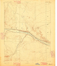
1893 Map of Nepesta
USGS Topo · Published 1893About this map
Arkansas River serves as the central artery of this 1889 survey, where the convergence of major watercourses and pioneering railroads shaped the early development of Pueblo and Otero counties. The landscape is defined by the parallel paths of the Atchison Topeka and Santa Fe Railroad and the Missouri Pacific Railroad, which follow the river valley eastward through Booneville and Nepesta. These rail lines were critical to the late-19th-century economy, connecting isolated outposts to the broader industrial network.
Find a feature on this map
18 named features on this map. Tap any name to fly to it.
Don’t see what you’re looking for? This feature index may not catch every label — zoom into the map to look around manually.
Map Details
Editions of this 1893 Nepesta Map
2 editions found
Other maps of this area

1889 · Sanborn
USGS Topo · 1:125,000

1891 · Walsenburg
USGS Topo · 1:125,000

1891 · Sanborn
USGS Topo · 1:125,000

1891 · Catlin
USGS Topo · 1:125,000

1891 · Pueblo
USGS Topo · 1:125,000

1891 · Timpas
USGS Topo · 1:125,000

1891 · Nepesta
USGS Topo · 1:125,000

1891 · Apishapa
USGS Topo · 1:125,000

1893 · Sanborn
USGS Topo · 1:125,000

1893 · Apishapa
USGS Topo · 1:125,000