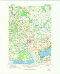
1963 Map of Neshkoro
USGS Topo · Published 1973About this map
Fox River and the Mecan River converge in this central Wisconsin landscape, forming a complex network of wetlands and waterways during the early 1960s. The region is anchored by the larger settlements of Neshkoro and Princeton, the latter of which serves as a hub where the Chicago And North Western railroad crosses the river. The map details a rural society organized around small schools like Rabbit Sch and numerous country burial grounds, including Mt Tom Cem and Dayton Cem. To the southeast, the deep waters of Green Lake meet the shoreline community of Green Lake Terrace, while the southwestern corner is dominated by the broad expanse of Puckaway Lake. This era shows the persistence of small-scale agriculture and early aviation, marked by the Bed And Von Landing Field, alongside numerous Gravel Pits that suggest local industrial activity.
Find a feature on this map
64 named features on this map. Tap any name to fly to it.
Don’t see what you’re looking for? This feature index may not catch every label — zoom into the map to look around manually.
Map Details
Editions of this 1963 Neshkoro Map
2 editions found

Other maps of this area

1902 · Portage
USGS Topo · 1:62,500

1915 · Neshkoro
USGS Topo · 1:48,000

1916 · Ripon
USGS Topo · 1:48,000

1918 · Neshkoro
USGS Topo · 1:62,500

1918 · Ripon
USGS Topo · 1:62,500

1955 · Randolph
USGS Topo · 1:62,500

1955 · Fox Lake
USGS Topo · 1:62,500

1955 · Green Bay
USGS Topo · 1:250,000

1956 · Ripon
USGS Topo · 1:62,500

1957 · Madison
USGS Topo · 1:250,000