
1963 Map of Neshkoro
USGS Topo · Published 1964About this map
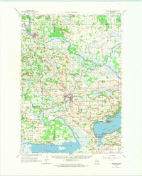
The Fox River and its winding tributaries, including the Mecan River and White River, define the landscape of this Central Wisconsin region in the early 1960s. The city of Princeton sits at a geographic crossroads, where the Chicago and North Western railroad meets the water. Nearby, the Bed-ah-Wick Landing Field suggests the evolving transportation needs of the mid-century. Further north, the village of Neshkoro and the small settlement of Bannerman anchor the rural landscape, which is dotted with neighborhood landmarks like the Rabbitt Sch and Borth Sch.
Find a feature on this map
67 named features on this map. Tap any name to fly to it.
Don’t see what you’re looking for? This feature index may not catch every label — zoom into the map to look around manually.
Map Details
Editions of this 1963 Neshkoro Map
2 editions found
Other maps of this area

1902 · Portage
USGS Topo · 1:62,500

1915 · Neshkoro
USGS Topo · 1:48,000

1916 · Ripon
USGS Topo · 1:48,000

1918 · Neshkoro
USGS Topo · 1:62,500

1918 · Ripon
USGS Topo · 1:62,500

1955 · Randolph
USGS Topo · 1:62,500

1955 · Fox Lake
USGS Topo · 1:62,500

1955 · Green Bay
USGS Topo · 1:250,000

1956 · Ripon
USGS Topo · 1:62,500

1957 · Madison
USGS Topo · 1:250,000