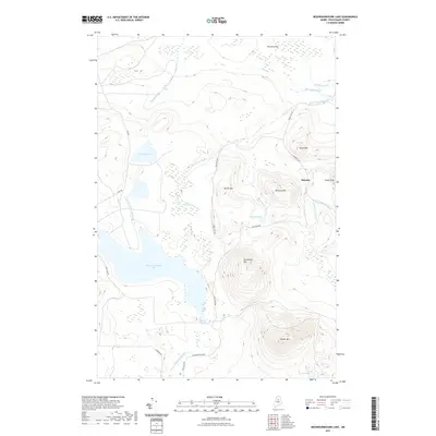
2021 Map of Nesowadnehunk Lake
USGS Topo · Published 2021About this map
Nesowadnehunk Lake dominates the central landscape of this Piscataquis County quadrangle, situated within a high-elevation drainage basin defined by prominent peaks. The settlement at McCarty marks a historic point of human presence amidst the complex network of brooks and bogs, including Kennedy Bog and the Black Spruce Bog. Significant topographic features rise sharply from the valley floor, most notably Strickland Mtn, McCarty Mtn, and Center Mtn. The transport network relies on primitive corridors such as Park Tote Rd and Perimeter Rd, which follow the contours of the terrain to connect isolated points. Hydrological patterns are defined by the Nesowadnehunk Stream and numerous alpine water bodies like Dwelley Pond and Thissell Pond, reflecting a wilderness character shaped by glacial geography and the headwaters of the North Maine Woods.
Find a feature on this map
27 named features on this map. Tap any name to fly to it.
Don’t see what you’re looking for? This feature index may not catch every label — zoom into the map to look around manually.
Map Details
Editions of this 2021 Nesowadnehunk Lake Map
This is the sole edition of this map. No revisions or reprints were ever made.
Other maps of this area

1927 · Katahdin
USGS Topo · 1:48,000

1930 · Katahdin
USGS Topo · 1:62,500

1949 · Katahdin
USGS Topo · 1:62,500

1953 · Telos Lake
USGS Topo · 1:62,500

1954 · Harrington Lake
USGS Topo · 1:62,500

1954 · Presque Isle
USGS Topo · 1:250,000

1954 · Millinocket
USGS Topo · 1:250,000

1955 · Traveler Mountain
USGS Topo · 1:62,500

1957 · Telos Lake
USGS Topo · 1:62,500

1958 · Presque Isle
USGS Topo · 1:250,000