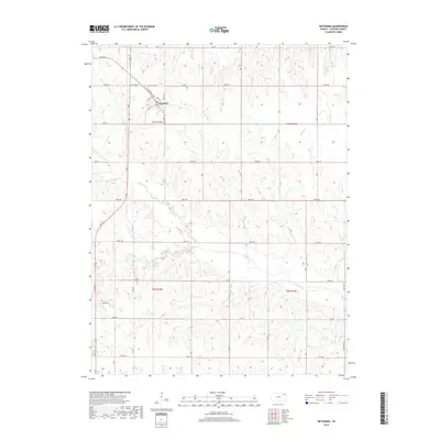
2018 Map of Netawaka
USGS Topo · Published 2018About this map
Netawaka sits at the intersection of local history and the Kansas prairie, centered around a traditional grid of named streets such as Commercial St, Kansas Ave, and Main St. This Jackson County settlement serves as the anchor for a rural landscape defined by section-line roads and the winding paths of local waterways. To the north of the town center lies the Netawaka Cem, a vital point of interest for researchers tracking family lineages in the region. The surrounding terrain is shaped by the drainage patterns of Mosquito Cr and Spring Cr in the north, while Straight Cr and Negro Cr carve through the southern sections. The map preserves the specific road nomenclature of the late 2010s, showing a transition between named village streets and the numbered grid system of the countryside, including routes like White Way St.
Find a feature on this map
33 named features on this map. Tap any name to fly to it.
Don’t see what you’re looking for? This feature index may not catch every label — zoom into the map to look around manually.
Map Details
Editions of this 2018 Netawaka Map
This is the sole edition of this map. No revisions or reprints were ever made.
Other maps of this area

1888 · Hiawatha
USGS Topo · 1:125,000

1889 · Topeka
USGS Topo · 1:125,000

1894 · Topeka
USGS Topo · 1:125,000

1894 · Hiawatha
USGS Topo · 1:125,000

1950 · Kansas City
USGS Topo · 1:250,000

1954 · Kansas City
USGS Topo · 1:250,000

1956 · Kansas City
USGS Topo · 1:250,000

1960 · Kansas City
USGS Topo · 1:250,000
1960 · Holton
USGS Topo · 1:24,000
1960 · Arrington
USGS Topo · 1:24,000