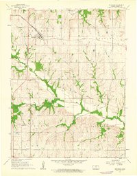
1961 Map of Netawaka
USGS Topo · Published 1962About this map
Netawaka stands as a rail-centered hub in northern Jackson County, situated at the intersection of the Missouri Pacific and several primary townships. The landscape is defined by its drainage into Straight Creek and Muddy Creek, reflecting a rural agricultural pattern common in the early 1960s. A significant historical marker, the Old Indian Boundary, cuts across the terrain, preserving the memory of previous land divisions in the topography.
Find a feature on this map
18 named features on this map. Tap any name to fly to it.
Don’t see what you’re looking for? This feature index may not catch every label — zoom into the map to look around manually.
Map Details
Editions of this 1961 Netawaka Map
This is the sole edition of this map. No revisions or reprints were ever made.
Other maps of this area

1888 · Hiawatha
USGS Topo · 1:125,000

1889 · Topeka
USGS Topo · 1:125,000

1894 · Topeka
USGS Topo · 1:125,000

1894 · Hiawatha
USGS Topo · 1:125,000

1950 · Kansas City
USGS Topo · 1:250,000

1954 · Kansas City
USGS Topo · 1:250,000

1956 · Kansas City
USGS Topo · 1:250,000

1960 · Kansas City
USGS Topo · 1:250,000
1960 · Holton
USGS Topo · 1:24,000
1960 · Arrington
USGS Topo · 1:24,000