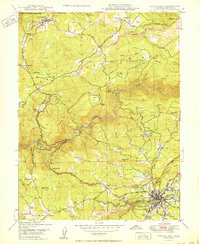
1950 Map of Nevada City
USGS Topo · Published 1950About this map
Nevada City serves as the focal point of this Gold Country landscape, situated at the base of Cement Hill and Harmony Ridge. The map documents a transition in the local economy, where legacy hydraulic and hard-rock operations like the Cherokee Diggings and Champion Mine coexist with early aviation at the Nevada City Airport. The terrain is deeply carved by the South Yuba River, which flows past the prominent Devils Slide. To the north, the San Juan Ridge hosts a string of settlements including North San Juan, Sebastopol, and Sweetland. This 1950 edition illustrates the complex water management system vital to the region, featuring the Excelsior Ditch and Rough and Ready Ditch winding through the hills. Numerous family-named properties, such as Robinson Ranch and Hilliard Ranch, are scattered among the ridges, providing a detailed record of mid-century land ownership and rural settlement patterns.
Find a feature on this map
57 named features on this map. Tap any name to fly to it.
Don’t see what you’re looking for? This feature index may not catch every label — zoom into the map to look around manually.
Map Details
Editions of this 1950 Nevada City Map
This is the sole edition of this map. No revisions or reprints were ever made.
Other maps of this area

1888 · Smartsville
USGS Topo · 1:125,000

1891 · Colfax
USGS Topo · 1:125,000

1891 · Smartsville
USGS Topo · 1:125,000

1892 · Smartsville
USGS Topo · 1:125,000

1892 · Colfax
USGS Topo · 1:125,000

1894 · Colfax
USGS Topo · 1:125,000

1894 · Smartsville
USGS Topo · 1:125,000

1895 · Smartsville
USGS Topo · 1:125,000

1898 · Colfax
USGS Topo · 1:125,000

1900 · Colfax
USGS Topo · 1:125,000