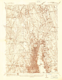
1936 Map of New Bedford North
USGS Topo · Published 1936About this map
The dense grid of New Bedford and Fairhaven Center defines the southern portion of this 1936 survey, where urban development meets the tidal waters of Buzzards Bay. The Acushnet River serves as a central artery between these growing industrial centers, flanked by landmarks such as Fort Phoenix and Riverside Cem. Moving inland, the landscape shifts dramatically into the vast wetlands of the Acushnet Cedar Swamp and Apponagansett Cedar Swamp, illustrating the natural barriers that constrained early suburban expansion.
Find a feature on this map
69 named features on this map. Tap any name to fly to it.
Don’t see what you’re looking for? This feature index may not catch every label — zoom into the map to look around manually.
Map Details
Editions of this 1936 New Bedford North Map
This is the sole edition of this map. No revisions or reprints were ever made.
Other maps of this area

1885 · New Bedford
USGS Topo · 1:62,500

1885 · Middleboro
USGS Topo · 1:62,500

1885 · Taunton
USGS Topo · 1:62,500

1888 · New Bedford
USGS Topo · 1:62,500

1888 · Fall River
USGS Topo · 1:62,500

1888 · Taunton
USGS Topo · 1:62,500

1888 · Middleboro
USGS Topo · 1:62,500

1893 · Taunton
USGS Topo · 1:62,500

1893 · Middleboro
USGS Topo · 1:62,500

1893 · Fall River
USGS Topo · 1:62,500