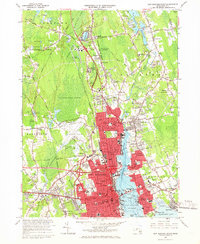
1964 Map of New Bedford North
USGS Topo · Published 1966About this map
The Acushnet River serves as the industrial and social spine of this 1960s coastal landscape, separating the dense urban grid of New Bedford from the residential and cemetery-dotted shores of Fairhaven. Large infrastructure projects define the era, including the expanding Municipal Airport and the campus of the Southeastern Mass Technological Institute. To the north, the terrain shifts into a complex of wetlands and woodlands, dominated by the Acushnet Cedar Swamp and the Hathaway Swamp, providing a stark contrast to the heavily developed waterfront. Small neighborhoods like Braleys and Clifford are interspersed with numerous gravel pits and the prominent Sassaquin Hospital grounds. This sheet captures a critical moment of post-war suburban growth, showing emerging neighborhoods like Westgate Park and Sherwood Forest as they pushed into the traditional cranberry-producing regions of the northern interior.
Find a feature on this map
104 named features on this map. Tap any name to fly to it.
Don’t see what you’re looking for? This feature index may not catch every label — zoom into the map to look around manually.
Map Details
Editions of this 1964 New Bedford North Map
This is the sole edition of this map. No revisions or reprints were ever made.
Other maps of this area

1885 · New Bedford
USGS Topo · 1:62,500

1885 · Middleboro
USGS Topo · 1:62,500

1885 · Taunton
USGS Topo · 1:62,500

1888 · New Bedford
USGS Topo · 1:62,500

1888 · Fall River
USGS Topo · 1:62,500

1888 · Taunton
USGS Topo · 1:62,500

1888 · Middleboro
USGS Topo · 1:62,500

1893 · Taunton
USGS Topo · 1:62,500

1893 · Middleboro
USGS Topo · 1:62,500

1893 · Fall River
USGS Topo · 1:62,500