1979 Map of New Bedford North
USGS Topo · Published 1979About this map
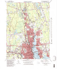
New Bedford and the surrounding coastal communities of Fairhaven and Acushnet are captured here in the late 1970s, showcasing a landscape defined by its deep-water harbor and extensive wetlands. The city's industrial and transportation infrastructure is prominent, from the New Bedford Municipal Airport and Bedford Industrial Park to the numerous wharves and the State Pier along the Acushnet River. The map details a transition from dense urban grids to the sprawling Acushnet Cedar Swamp State Reservation and numerous cranberry bogs to the north.
Find a feature on this map
167 named features on this map. Tap any name to fly to it.
Don’t see what you’re looking for? This feature index may not catch every label — zoom into the map to look around manually.
Map Details
Editions of this 1979 New Bedford North Map
2 editions found

Other maps of this area

1885 · New Bedford
USGS Topo · 1:62,500

1885 · Middleboro
USGS Topo · 1:62,500

1885 · Taunton
USGS Topo · 1:62,500

1888 · New Bedford
USGS Topo · 1:62,500

1888 · Fall River
USGS Topo · 1:62,500

1888 · Taunton
USGS Topo · 1:62,500

1888 · Middleboro
USGS Topo · 1:62,500

1893 · Taunton
USGS Topo · 1:62,500

1893 · Middleboro
USGS Topo · 1:62,500

1893 · Fall River
USGS Topo · 1:62,500