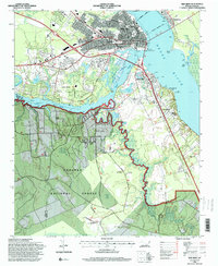
1994 Map of New Bern
USGS Topo · Published 2000About this map
The confluence of the Neuse River and Trent River anchors this detailed study of the coastal plains, showing the expansion of New Bern and its surrounding communities in the mid-1990s. The city core is dense with history, featuring numerous burial grounds like Cedar Grove Cem and Greenwood Cem, alongside the civic heart of the Court house and Union Point. Across the water, James City and Bridgeton line the shorelines, while the southern half of the map is dominated by the dense, winding hydrology of Brices Creek as it carves through the Croatan National Forest. The landscape reveals a transition from the urban grid of Pollock St and Queen St to the sprawling outskirts of Trent Woods and the aviation infrastructure at Simmons-Nott Airport. This map is particularly useful for tracing the 20th-century development of the waterfront and the preservation of forest lands against the rising residential footprint.
Find a feature on this map
51 named features on this map. Tap any name to fly to it.
Don’t see what you’re looking for? This feature index may not catch every label — zoom into the map to look around manually.
Map Details
Editions of this 1994 New Bern Map
3 editions found
Other maps of this area

1901 · New Bern
USGS Topo · 1:62,500

1903 · New Bern
USGS Topo · 1:62,500

1942 · Maysville
USGS Topo · 1:62,500

1948 · Maysville
USGS Topo · 1:62,500

1949 · Havelock
USGS Topo · 1:24,000

1950 · Pollocksville
USGS Topo · 1:24,000

1950 · New Bern
USGS Topo · 1:24,000

1950 · Upper Broad Creek
USGS Topo · 1:24,000

1951 · Upper Broad Creek
USGS Topo · 1:24,000

1953 · Rocky Mount
USGS Topo · 1:250,000