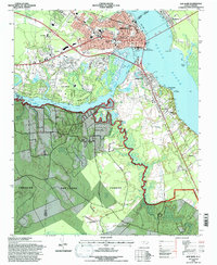
1994 Map of New Bern
USGS Topo · Published 1997About this map
New Bern sits at the significant confluence of the Neuse River and Trent River, serving as a focal point for this coastal North Carolina landscape. The city's historical footprint is deeply etched into the terrain, from the National Cemetery and Cedar Grove Cemetery to the established residential patterns of Craven Terrace and De Graffenried Park. To the south, the expansive Croatan National Forest begins, dominated by the winding course of Brice Creek and Hayward Creek. This 1994 revision captures the area's mid-century infrastructure, including the Simmons-Nott Airport and the Norfolk Southern railway lines that bypass the downtown core. The map highlights the transition from the dense urban grid of the historic port to suburban developments like Trent Woods and the surrounding riverfront communities of Bridgeton and James City.
Find a feature on this map
45 named features on this map. Tap any name to fly to it.
Don’t see what you’re looking for? This feature index may not catch every label — zoom into the map to look around manually.
Map Details
Editions of this 1994 New Bern Map
3 editions found
Other maps of this area

1901 · New Bern
USGS Topo · 1:62,500

1903 · New Bern
USGS Topo · 1:62,500

1942 · Maysville
USGS Topo · 1:62,500

1948 · Maysville
USGS Topo · 1:62,500

1949 · Havelock
USGS Topo · 1:24,000

1950 · Pollocksville
USGS Topo · 1:24,000

1950 · New Bern
USGS Topo · 1:24,000

1950 · Upper Broad Creek
USGS Topo · 1:24,000

1951 · Upper Broad Creek
USGS Topo · 1:24,000

1953 · Rocky Mount
USGS Topo · 1:250,000