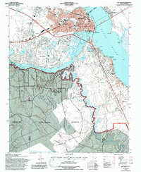
1994 Map of New Bern
USGS Topo · Published 1997About this map
The Neuse River and Trent River converge at the heart of New Bern, defining the city’s historic layout and waterfront character during the mid-1990s. The urban core is detailed with civic landmarks like the Courthouse, Union Point, and Craven Terrace, while the surrounding landscape reflects a mix of suburban growth in Trent Woods and industrial transport along the Atlantic and East Carolina RR. This survey provides significant genealogical value, documenting numerous burial grounds including the National Cem, Cedar Grove Cem, and Barn Cem. South of the rivers, the geography transitions into the dense woodlands of the Croatan National Forest, where the winding course of Brices Creek carves through the timberland. This document captures the city just before the turn of the millennium, showing the proximity of historic urban neighborhoods to the sprawling Simmons-Nott Airport and newer developments like James City.
Find a feature on this map
55 named features on this map. Tap any name to fly to it.
Don’t see what you’re looking for? This feature index may not catch every label — zoom into the map to look around manually.
Map Details
Editions of this 1994 New Bern Map
3 editions found
Other maps of this area

1901 · New Bern
USGS Topo · 1:62,500

1903 · New Bern
USGS Topo · 1:62,500

1942 · Maysville
USGS Topo · 1:62,500

1948 · Maysville
USGS Topo · 1:62,500

1949 · Havelock
USGS Topo · 1:24,000

1950 · Pollocksville
USGS Topo · 1:24,000

1950 · New Bern
USGS Topo · 1:24,000

1950 · Upper Broad Creek
USGS Topo · 1:24,000

1951 · Upper Broad Creek
USGS Topo · 1:24,000

1953 · Rocky Mount
USGS Topo · 1:250,000