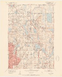
1952 Map of New Brighton
USGS Topo · Published 1954About this map
The Twin Cities Arsenal dominates the center of this landscape during the early 1950s, highlighting the massive industrial and military footprint north of Minneapolis. The region is defined by a dense network of water bodies and mid-century suburban expansion, where residential pockets like Fridley and New Brighton are interwoven with numerous lakes including Lake Johanna, Turtle Lake, and Lake Owasso. The transportation infrastructure is particularly complex, featuring the Minnesota Transfer Ry and the Sault Ste Marie and railroad lines meeting at Hilo Junction.
Find a feature on this map
79 named features on this map. Tap any name to fly to it.
Don’t see what you’re looking for? This feature index may not catch every label — zoom into the map to look around manually.
Map Details
Editions of this 1952 New Brighton Map
2 editions found

Other maps of this area

1896 · Minneapolis
USGS Topo · 1:62,500

1896 · St. Paul
USGS Topo · 1:62,500

1901 · Minneapolis
USGS Topo · 1:62,500

1902 · White Bear
USGS Topo · 1:62,500

1902 · Anoka
USGS Topo · 1:62,500

1951 · St. Paul West
USGS Topo · 1:24,000

1951 · St. Paul East
USGS Topo · 1:24,000

1951 · St. Paul
USGS Topo · 1:62,500

1952 · Centerville
USGS Topo · 1:24,000

1952 · White Bear Lake West
USGS Topo · 1:24,000