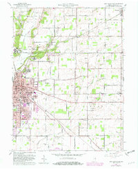
1960 Map of New Castle East
USGS Topo · Published 1982About this map
The Indiana Village for Epileptics dominates the northwestern portion of this Henry County survey, featuring several distinct campuses including Colony No 1, Colony No 2, and Colony No 3 near the settlement of Van Nuys. The landscape is a mix of agricultural fields and small residential clusters, with the city of New Castle expanding eastward toward the New Castle Municipal Airport. Waterways such as the Big Blue River and Flatrock River drain the region, flanked by numerous small runs like Moonshine Run and Lavender Run. In the south, the Norfolk and Western railroad corridor passes through Ashland and Millville, while the northern reaches include the community of Mooreland. Local social foundations are well-marked by landmarks like the Ashland Sch, South Mound Cem, and White Heart Ch.
Find a feature on this map
58 named features on this map. Tap any name to fly to it.
Don’t see what you’re looking for? This feature index may not catch every label — zoom into the map to look around manually.
Map Details
Editions of this 1960 New Castle East Map

Other maps of this area

1948 · Lewisville
USGS Topo · 1:24,000

1949 · New Castle West
USGS Topo · 1:24,000

1950 · New Castle East
USGS Topo · 1:24,000

1950 · Dunreith
USGS Topo · 1:24,000

1950 · Lewisville
USGS Topo · 1:24,000

1953 · Cincinnati
USGS Topo · 1:250,000

1953 · Muncie
USGS Topo · 1:250,000

1956 · Muncie
USGS Topo · 1:250,000

1957 · Cincinnati
USGS Topo · 1:250,000

1960 · New Castle West
USGS Topo · 1:24,000