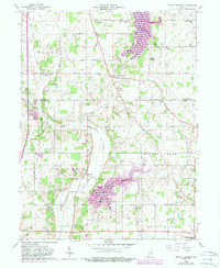
1960 Map of Mount Pleasant
USGS Topo · Published 1988About this map
The agricultural landscape of Delaware Co and Henry Co is defined by its transition toward water management and infrastructure by the mid-20th century. The presence of the large Prairie Creek Reservoir and the Summit Lake Reservoir indicates significant shifts in the regional watershed, impacting the areas surrounding Stoney Creek and the Blue River. The map documents a scattered network of small communities such as Luray, Rogersville, and Mooreland, connected by a grid of county roads and the Chesapeake and Ohio RR.
Find a feature on this map
53 named features on this map. Tap any name to fly to it.
Don’t see what you’re looking for? This feature index may not catch every label — zoom into the map to look around manually.
Map Details
Editions of this 1960 Mount Pleasant Map
4 editions found

Other maps of this area

1949 · New Castle West
USGS Topo · 1:24,000

1950 · New Castle East
USGS Topo · 1:24,000

1952 · Muncie East
USGS Topo · 1:24,000

1952 · Farmland
USGS Topo · 1:24,000

1952 · Muncie West
USGS Topo · 1:24,000

1953 · Cincinnati
USGS Topo · 1:250,000

1953 · Muncie
USGS Topo · 1:250,000

1956 · Muncie
USGS Topo · 1:250,000

1957 · Cincinnati
USGS Topo · 1:250,000

1960 · New Castle West
USGS Topo · 1:24,000