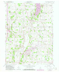
1960 Map of Mount Pleasant
USGS Topo · Published 1982About this map
Summit Lake Reservoir and Prairie Creek Reservoir dominate this eastern Indiana landscape, reflecting mid-century water management projects across the Delaware and Henry County line. The map captures a moment of transition where purple hatching indicates areas planned for submergence, fundamentally altering the local terrain around Prairie Run and the Blue River. Between these rising waters, the Chesapeake and Ohio railroad cuts a diagonal path through the countryside, serving small agrarian hubs like Mount Pleasant and Rogersville. A dense network of family-named cemeteries and rural institutions, such as Macedonia Cem and Harris Chapel, provides a detailed record of the long-standing community footprint in Monroe and Prairie townships. This 1960 survey, updated in the early 1980s, offers a clear view of the rural infrastructure before modern development further modified the drainage patterns of Buck Creek and the Big Blue River.
Find a feature on this map
59 named features on this map. Tap any name to fly to it.
Don’t see what you’re looking for? This feature index may not catch every label — zoom into the map to look around manually.
Map Details
Editions of this 1960 Mount Pleasant Map
4 editions found

Other maps of this area

1949 · New Castle West
USGS Topo · 1:24,000

1950 · New Castle East
USGS Topo · 1:24,000

1952 · Muncie East
USGS Topo · 1:24,000

1952 · Farmland
USGS Topo · 1:24,000

1952 · Muncie West
USGS Topo · 1:24,000

1953 · Cincinnati
USGS Topo · 1:250,000

1953 · Muncie
USGS Topo · 1:250,000

1956 · Muncie
USGS Topo · 1:250,000

1957 · Cincinnati
USGS Topo · 1:250,000

1960 · New Castle West
USGS Topo · 1:24,000