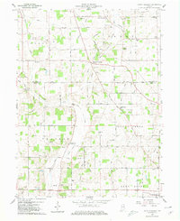
1960 Map of Mount Pleasant
USGS Topo · Published 1980About this map
Medford and Mount Pleasant anchor this agricultural landscape along the border of Delaware and Henry Counties at the start of the 1960s. The Chesapeake and Ohio railroad cuts a diagonal path through the northern half of the region, connecting the small settlements of New Burlington and Medford to the wider grain-and-rail economy of east-central Indiana. The terrain is defined by a dense network of drainage, including Buck Creek, Prairie Creek, and the headwaters of the Blue River, illustrating how local hydrology shaped the early settlement patterns and road placements.
Find a feature on this map
49 named features on this map. Tap any name to fly to it.
Don’t see what you’re looking for? This feature index may not catch every label — zoom into the map to look around manually.
Map Details
Editions of this 1960 Mount Pleasant Map
4 editions found

Other maps of this area

1949 · New Castle West
USGS Topo · 1:24,000

1950 · New Castle East
USGS Topo · 1:24,000

1952 · Muncie East
USGS Topo · 1:24,000

1952 · Farmland
USGS Topo · 1:24,000

1952 · Muncie West
USGS Topo · 1:24,000

1953 · Cincinnati
USGS Topo · 1:250,000

1953 · Muncie
USGS Topo · 1:250,000

1956 · Muncie
USGS Topo · 1:250,000

1957 · Cincinnati
USGS Topo · 1:250,000

1960 · New Castle West
USGS Topo · 1:24,000