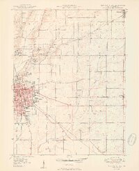
1950 Map of New Castle East
USGS Topo · Published 1950About this map
The Indiana Village for Epileptics dominates the northwest corner of this Henry County landscape, organized into numbered colonies such as Colony No 1 and Colony No 3. This institutional complex, including the Van Nuys settlement, highlights early 20th-century approaches to state-managed care. To the south, the city of New Castle exhibits a dense grid of residential and industrial development, supported by a significant convergence of rail lines including the Pennsylvania and the New York Chicago and St Louis. The surrounding countryside is dotted with rural centers like Ashland and Millville, where small schools like Ashland Sch and churches like Batson Ch served local farming families. Notable landmarks such as the Municipal Airport and Baker Park reflect the mid-century growth of the county seat.
Find a feature on this map
39 named features on this map. Tap any name to fly to it.
Don’t see what you’re looking for? This feature index may not catch every label — zoom into the map to look around manually.
Map Details
Editions of this 1950 New Castle East Map
2 editions found
Other maps of this area

1948 · Lewisville
USGS Topo · 1:24,000

1949 · New Castle West
USGS Topo · 1:24,000

1950 · New Castle East
USGS Topo · 1:24,000

1950 · Dunreith
USGS Topo · 1:24,000

1950 · Lewisville
USGS Topo · 1:24,000

1953 · Cincinnati
USGS Topo · 1:250,000

1953 · Muncie
USGS Topo · 1:250,000

1956 · Muncie
USGS Topo · 1:250,000

1957 · Cincinnati
USGS Topo · 1:250,000

1960 · New Castle West
USGS Topo · 1:24,000