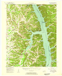
1955 Map of New Concord
USGS Topo · Published 1957About this map
The Kentucky Lake Tennessee River dominates the landscape of Calloway County in the mid-1950s, following the creation of the massive reservoir that transformed the local geography. The map reveals a dense network of rural communities and crossroads such as New Concord, Faxon, and Pottertown, many of which are anchored by local spiritual life at Russell Chapel, Friendship Ch, and New Mt Carmel Ch. To the east, the area known as Between the Rivers shows a less settled, more wooded character, including the Kentucky Woodlands Wildlife Refuge. This era captures the transition of the region into a recreational and conservation hub, evidenced by the Irvin Cobb Resort and the Kentucky State Park lands. Genealogists can trace family footprints through numerous cemeteries and small rural education centers like Independence Sch and Faxon Sch situated along the winding creek valleys.
Find a feature on this map
75 named features on this map. Tap any name to fly to it.
Don’t see what you’re looking for? This feature index may not catch every label — zoom into the map to look around manually.
Map Details
Editions of this 1955 New Concord Map
This is the sole edition of this map. No revisions or reprints were ever made.
Other maps of this area

1936 · Conyersville
USGS Topo · 1:24,000

1936 · Buchanan
USGS Topo · 1:24,000

1936 · Hazel
USGS Topo · 1:24,000

1936 · Tharpe
USGS Topo · 1:24,000

1936 · New Concord
USGS Topo · 1:24,000

1936 · Hamlin
USGS Topo · 1:24,000

1936 · Fenton
USGS Topo · 1:24,000

1936 · Hardin
USGS Topo · 1:24,000

1936 · Centerville Landing
USGS Topo · 1:24,000

1936 · Hiatt
USGS Topo · 1:24,000