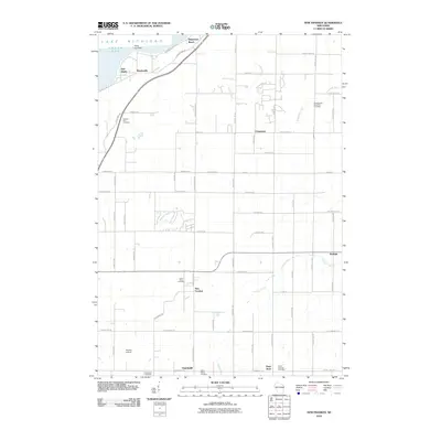
2010 Map of New Franken
USGS Topo · Published 2010About this map
The eastern shore of Green Bay at Point Comfort meets a grid of rural farmland and small hamlets in this 2010 survey. Settlements like New Franken, Champion, and Sugar Bush serve as central nodes for the surrounding agricultural community, where numerous houses of worship and burial grounds are meticulously documented. Genealogists will find high value in the inclusion of several family and community resting places, including Saint Killian Cemetery, Pleasant Hill Cemetery, and the Seventh-day Adventist Cemetery. The landscape is carved by several waterways, including School Creek and the Kewaunee River, which flow through a network of local roads such as Sturgeon Bay Rd and Nicolet Dr. Near the southern border, the Nicolet Airport and the community of Humboldt mark the transition toward more developed areas near the county line.
Find a feature on this map
69 named features on this map. Tap any name to fly to it.
Don’t see what you’re looking for? This feature index may not catch every label — zoom into the map to look around manually.
Map Details
Editions of this 2010 New Franken Map
This is the sole edition of this map. No revisions or reprints were ever made.
Other maps of this area

1952 · Casco
USGS Topo · 1:62,500

1954 · Kewaunee
USGS Topo · 1:62,500

1954 · Denmark
USGS Topo · 1:62,500

1954 · New Franken
USGS Topo · 1:62,500

1954 · Green Bay East
USGS Topo · 1:24,000

1954 · Manitowoc
USGS Topo · 1:250,000

1954 · Bellevue
USGS Topo · 1:24,000

1958 · Manitowoc
USGS Topo · 1:250,000
1974 · Little Tail Point
USGS Topo · 1:24,000

1978 · Namur
USGS Topo · 1:24,000