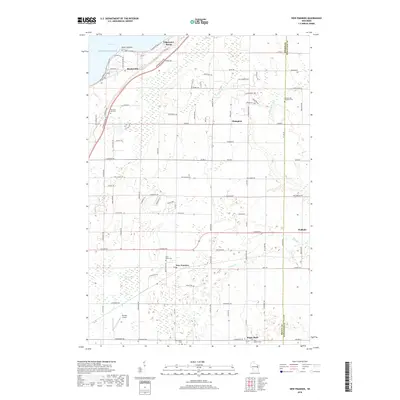
2018 Map of New Franken
USGS Topo · Published 2018About this map
Green Bay and the shoreline of Lake Michigan define the northwestern edge of this Wisconsin landscape, where several distinct coastal and inland settlements are documented. Communities such as Edgewater Beach, Benderville, and Champion are situated among a network of rural roads, while the interior is marked by the expansive New Franken Swamp. The map shows a clear pattern of local religious and genealogical history through numerous burial sites, including the Seventh-day Adventist Cem, Saint Killian Cem, and Pleasant Hill Cem. Transportation and commerce are represented by the Nicolet Airport and the winding paths of School Cr, Gibson Cr, and the Kewaunee River. The terrain transitions from the coastal elevations at Point Comfort to the agricultural reaches near Sugar Bush and Walhain, providing a detailed look at the rural infrastructure and land use in Brown and Kewaunee Counties.
Find a feature on this map
99 named features on this map. Tap any name to fly to it.
Don’t see what you’re looking for? This feature index may not catch every label — zoom into the map to look around manually.
Map Details
Editions of this 2018 New Franken Map
This is the sole edition of this map. No revisions or reprints were ever made.
Other maps of this area

1952 · Casco
USGS Topo · 1:62,500

1954 · Kewaunee
USGS Topo · 1:62,500

1954 · Denmark
USGS Topo · 1:62,500

1954 · New Franken
USGS Topo · 1:62,500

1954 · Green Bay East
USGS Topo · 1:24,000

1954 · Manitowoc
USGS Topo · 1:250,000

1954 · Bellevue
USGS Topo · 1:24,000

1958 · Manitowoc
USGS Topo · 1:250,000
1974 · Little Tail Point
USGS Topo · 1:24,000

1978 · Namur
USGS Topo · 1:24,000