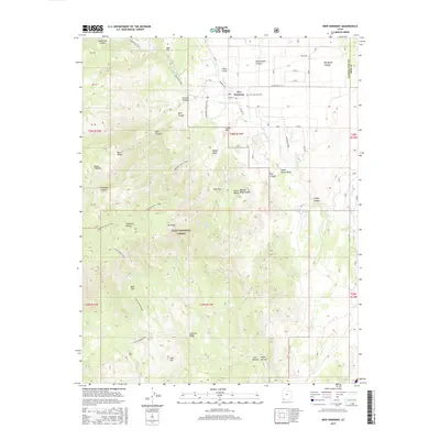
2017 Map of New Harmony
USGS Topo · Published 2017About this map
New Harmony sits at the base of the towering Kolob Terrace in a high-elevation landscape where the Great Basin meets the Colorado Plateau. This 2017 survey shows the settlement's historic core, including the New Harmony Cem, positioned near the junction of Pinto Cr and N Ash Cr. The map highlights the town's position relative to the sprawling Dixie National Forest and the rugged canyonlands to the west. Evidence of the area's agricultural and ranching roots is visible in the network of canals and the labeling of landmarks like Syler Flat and Anderson Valley. Extensive trails, such as the Anderson Valley Trail and the Syler Spring Trail, wind through the steep terrain, providing access to remote locations like Mt Baldy and Comanche Spring. The map also captures the stark contrast between the alluvial plains and the sharp rises of Coal Hill and Little Mtn.
Find a feature on this map
60 named features on this map. Tap any name to fly to it.
Don’t see what you’re looking for? This feature index may not catch every label — zoom into the map to look around manually.
Map Details
Editions of this 2017 New Harmony Map
This is the sole edition of this map. No revisions or reprints were ever made.
Other maps of this area

1885 · St. George
USGS Topo · 1:250,000

1891 · St. George
USGS Topo · 1:250,000

1950 · Kanarraville
USGS Topo · 1:24,000

1950 · Iron Mountain
USGS Topo · 1:62,500

1950 · Cedar City
USGS Topo · 1:62,500

1950 · Stoddard Mtn
USGS Topo · 1:24,000

1950 · Page Ranch
USGS Topo · 1:24,000

1951 · Kanarraville
USGS Topo · 1:24,000

1951 · Stoddard Mtn
USGS Topo · 1:24,000

1951 · Page Ranch
USGS Topo · 1:24,000