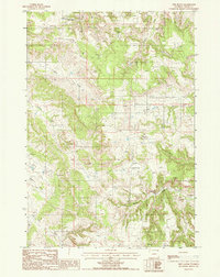
1984 Map of New Haven
USGS Topo · Published 1985About this map
New Haven serves as the focal point for this rural Crook County landscape during the mid-1980s. The settlement pattern is defined by scattered outposts such as Barnard and Barlow, connected by a network of improved and unimproved roads. The terrain is deeply carved by watercourses, including Muskrat Creek and Elkhorn Creek, which feed into the wider drainage system of the region. Local industry and infrastructure are represented by a Gravel Pit near the northern border and a Pumping Station along a marked pipeline. Genealogists may find interest in the isolated Cem located near Muskrat Creek, while landmarks like Sawmill Gulch and Butte Divide illustrate the topographical transitions between elevated plateaus and the lower creek basins. Numerous wells, including a specific Flowing Well in the western reaches, indicate the vital role of groundwater management for ranching and settlement in this portion of Wyoming.
Find a feature on this map
23 named features on this map. Tap any name to fly to it.
Don’t see what you’re looking for? This feature index may not catch every label — zoom into the map to look around manually.
Map Details
Editions of this 1984 New Haven Map
This is the sole edition of this map. No revisions or reprints were ever made.
Other maps of this area

1905 · Devils Tower
USGS Topo · 1:125,000

1954 · Strawberry Hill
USGS Topo · 1:24,000

1954 · Storm Hill
USGS Topo · 1:24,000

1954 · Missouri Buttes
USGS Topo · 1:24,000

1954 · Gillette
USGS Topo · 1:250,000

1955 · Devils Tower
USGS Topo · 1:62,500

1955 · Gillette
USGS Topo · 1:250,000

1957 · Oshoto
USGS Topo · 1:62,500

1957 · Seely
USGS Topo · 1:62,500

1957 · Cedar Ridge
USGS Topo · 1:62,500