
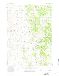
1957 Map of Oshoto
USGS Topo · Published 1959About this map
The Little Missouri River meanders through this Wyoming landscape, defining a ranching and homesteading region marked by the historic Texas Trail. In the late 1950s, the small settlement of Oshoto served as a local hub, anchored by the Oshoto Sch and the nearby Oshoto Reservoir. The map reveals a community-centered topography where rural education was a priority, evidenced by scattered schoolhouses including Rathbun Sch, Barlow Canyon Sch, and the Lower Cabin Creek Sch in the southern reaches. Distinctive terrain features like the Missouri Buttes and the Weehinkle Divide rise above the drainage networks of Cabin Creek and Ash Creek. Evidence of local faith and gathering places persists in labels like Pine Grove Chapel and the small station at New Haven. The intricate system of draws, such as Gumbo Draw and Alkali Draw, illustrates the complex erosion patterns and water management needs of the high plains.
Find a feature on this map
59 named features on this map. Tap any name to fly to it.
Don’t see what you’re looking for? This feature index may not catch every label — zoom into the map to look around manually.
Map Details
Editions of this 1957 Oshoto Map
2 editions found
Other maps of this area

1905 · Devils Tower
USGS Topo · 1:125,000

1918 · Moorcroft
USGS Topo · 1:125,000

1918 · Moorcroft
USGS Topo · 1:62,500

1954 · Sunny Divide
USGS Topo · 1:24,000

1954 · Strawberry Hill
USGS Topo · 1:24,000

1954 · Storm Hill
USGS Topo · 1:24,000

1954 · Carlile
USGS Topo · 1:24,000

1954 · Missouri Buttes
USGS Topo · 1:24,000

1954 · Gillette
USGS Topo · 1:250,000

1955 · Devils Tower
USGS Topo · 1:62,500