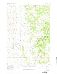
1957 Map of Oshoto
USGS Topo · Published 1975About this map
The Little Missouri River snakes through this high plains landscape of Crook County, anchoring a network of remote ranching outposts and drainage systems like Poison Creek and Alkali Draw. The map documents a sparsely populated ranching frontier where life revolved around small rural schoolhouses and family centers. Distinctive landmarks like the volcanic Missouri Buttes rise above the surrounding terrain, while the historic Texas Trail crosses the territory, marking the legacy of long-distance cattle drives.
Find a feature on this map
76 named features on this map. Tap any name to fly to it.
Don’t see what you’re looking for? This feature index may not catch every label — zoom into the map to look around manually.
Map Details
Editions of this 1957 Oshoto Map
2 editions found

Other maps of this area

1905 · Devils Tower
USGS Topo · 1:125,000

1918 · Moorcroft
USGS Topo · 1:125,000

1918 · Moorcroft
USGS Topo · 1:62,500

1954 · Sunny Divide
USGS Topo · 1:24,000

1954 · Strawberry Hill
USGS Topo · 1:24,000

1954 · Storm Hill
USGS Topo · 1:24,000

1954 · Carlile
USGS Topo · 1:24,000

1954 · Missouri Buttes
USGS Topo · 1:24,000

1954 · Gillette
USGS Topo · 1:250,000

1955 · Devils Tower
USGS Topo · 1:62,500