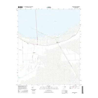
2016 Map of New Holland
USGS Topo · Published 2016About this map
Lake Mattamuskeet dominates the northern half of this coastal landscape, its shoreline bordered by Wildlife Dr and the community of New Holland. The area south of the lake is defined by an intricate network of engineered waterways, including the Hydeland Canal, Juniper Canal, and Outfall Canal, which drain the low-lying terrain toward Juniper Bay and the Phillips Canal. This pattern of drainage canals suggests a legacy of agricultural reclamation and water management essential for settlement in this part of Hyde County. Local family history is preserved at sites like Donald Farm Cem and Soule Cem near the junction of Mapletown Rd and Quarter Rd. Small settlements such as Hydeland are connected by a grid of rural routes including Juniper Bay Rd and Hydeland Rd, reflecting the remote, agrarian character of the region.
Find a feature on this map
20 named features on this map. Tap any name to fly to it.
Don’t see what you’re looking for? This feature index may not catch every label — zoom into the map to look around manually.
Map Details
Editions of this 2016 New Holland Map
This is the sole edition of this map. No revisions or reprints were ever made.
Other maps of this area

1943 · Columbia
USGS Topo · 1:125,000
1951 · Bluff Point
USGS Topo · 1:24,000

1951 · Middletown
USGS Topo · 1:24,000

1951 · Great Island
USGS Topo · 1:24,000

1951 · Engelhard West
USGS Topo · 1:24,000

1951 · New Holland
USGS Topo · 1:24,000

1951 · Swanquarter
USGS Topo · 1:24,000

1951 · Fairfield
USGS Topo · 1:24,000

1951 · New Lake SE
USGS Topo · 1:24,000

1953 · Rocky Mount
USGS Topo · 1:250,000