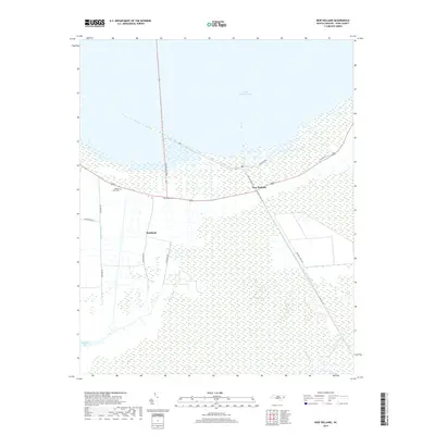
2019 Map of New Holland
USGS Topo · Published 2019About this map
Lake Mattamuskeet dominates the northern horizon of this coastal landscape, where the southern shore meets a complex network of drainage and transportation. The settlement of New Holland sits at the junction of the lake shore and the engineered waterways that define this corner of Hyde County. To the southwest, the community of Hydeland is surrounded by a grid of agricultural land and managed wetlands, connected by roads such as Mapletown Rd and Quarter Rd. This 2019 survey documents a terrain where water management is central to the human footprint, evidenced by the prominent Outfall Canal and Phillips Canal that cut through the low-lying marshes. Genealogists will find local landmarks like Donald Farm Cem and Soule Cem preserved alongside historic water access points like Frying Pan Lndg near the lake’s edge.
Find a feature on this map
21 named features on this map. Tap any name to fly to it.
Don’t see what you’re looking for? This feature index may not catch every label — zoom into the map to look around manually.
Map Details
Editions of this 2019 New Holland Map
This is the sole edition of this map. No revisions or reprints were ever made.
Other maps of this area

1943 · Columbia
USGS Topo · 1:125,000
1951 · Bluff Point
USGS Topo · 1:24,000

1951 · Middletown
USGS Topo · 1:24,000

1951 · Great Island
USGS Topo · 1:24,000

1951 · Engelhard West
USGS Topo · 1:24,000

1951 · New Holland
USGS Topo · 1:24,000

1951 · Swanquarter
USGS Topo · 1:24,000

1951 · Fairfield
USGS Topo · 1:24,000

1951 · New Lake SE
USGS Topo · 1:24,000

1953 · Rocky Mount
USGS Topo · 1:250,000