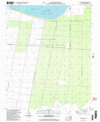
2002 Map of New Lake NW
USGS Topo · Published 2003About this map
Phelps Lake dominates the northern edge of this coastal landscape, providing a clear reference point where the shoreline meets the wooded wetlands of Pettigrew State Park. The interior is defined by the expansive Pocosin Lakes National Wildlife Refuge, a region characterized by its unique pocosin peatlands and drainage systems. A network of linear canals and service roads, including the Old State Canal, cuts through the terrain, reflecting historical efforts to manage the water levels of these low-lying areas. Situated at the intersection of Washington, Tyrrell, and Hyde Counties, the map documents a largely uninhabited wilderness where conservation boundaries are the primary landmarks. The absence of traditional settlements emphasizes the importance of these protected habitats in the North Carolina coastal plain as they appeared at the start of the 21st century.
Find a feature on this map
10 named features on this map. Tap any name to fly to it.
Don’t see what you’re looking for? This feature index may not catch every label — zoom into the map to look around manually.
Map Details
Editions of this 2002 New Lake NW Map
This is the sole edition of this map. No revisions or reprints were ever made.
Other maps of this area

1914 · Belhaven
USGS Topo · 1:48,000

1916 · Belhaven
USGS Topo · 1:62,500

1943 · Columbia
USGS Topo · 1:125,000

1943 · Plymouth
USGS Topo · 1:125,000

1951 · Belhaven
USGS Topo · 1:24,000

1951 · Ponzer
USGS Topo · 1:24,000

1951 · New Lake SE
USGS Topo · 1:24,000

1953 · Rocky Mount
USGS Topo · 1:250,000

1954 · Rocky Mount
USGS Topo · 1:250,000

1954 · Roper South
USGS Topo · 1:24,000