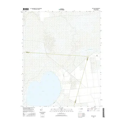
2016 Map of New Lake
USGS Topo · Published 2016About this map
New Lake dominates this coastal landscape, a large freshwater body surrounded by the characteristic wetlands of the Inner Banks. The boundary between Tyrrell County and Hyde County cuts directly across the northern reaches of the water, illustrating the administrative divisions that have defined this rural area for generations. The map reveals an intricate network of waterways designed for drainage and navigation, including the Dunbar Canal, Old State Canal, and the New Lake Fork. These man-made features, alongside natural flows like the Southwest Fork Alligator River, highlight the long history of managing this low-lying terrain for agriculture or timber. New Lake Rd and the elevated ground of Long Ridge provide the few points of terrestrial orientation in an otherwise aquatic and marsh-dominated environment.
Find a feature on this map
9 named features on this map. Tap any name to fly to it.
Don’t see what you’re looking for? This feature index may not catch every label — zoom into the map to look around manually.
Map Details
Editions of this 2016 New Lake Map
This is the sole edition of this map. No revisions or reprints were ever made.
Other maps of this area

1943 · Columbia
USGS Topo · 1:125,000

1951 · Fairfield
USGS Topo · 1:24,000

1951 · Ponzer
USGS Topo · 1:24,000

1951 · New Lake SE
USGS Topo · 1:24,000

1953 · Scotia
USGS Topo · 1:24,000

1953 · Fairfield NW
USGS Topo · 1:24,000

1953 · Rocky Mount
USGS Topo · 1:250,000

1954 · Rocky Mount
USGS Topo · 1:250,000
1954 · Creswell
USGS Topo · 1:24,000
1954 · Creswell SE
USGS Topo · 1:24,000