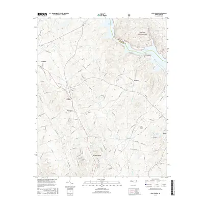
2016 Map of New London
USGS Topo · Published 2016About this map
The town of New London serves as a central hub in this section of Stanly County, where the landscape transitions from residential clusters to the dense timber of the Uwharrie National Forest. The northern reach of Albemarle is visible at the map's southern edge, while the settlements of Richfield, Palestine, and Whitney illustrate the historical community patterns of the Piedmont. The eastern boundary is defined by the significant waters of Badin Lake and the Tuckertown Reservoir, along with the Montgomery and Stanly county line. This map details a region defined by its hydrography and infrastructure, including the Stanly County Airport and a network of family-named roads like Kendalls Church Rd and Burris Burleson Rd. The presence of several smaller water bodies such as Reservoir Lake and Dafor Lake highlights the managed water resources essential to local development and recreation.
Find a feature on this map
122 named features on this map. Tap any name to fly to it.
Don’t see what you’re looking for? This feature index may not catch every label — zoom into the map to look around manually.
Map Details
Editions of this 2016 New London Map
This is the sole edition of this map. No revisions or reprints were ever made.
Other maps of this area

1949 · High Rock
USGS Topo · 1:24,000

1953 · Charlotte
USGS Topo · 1:250,000

1954 · Charlotte
USGS Topo · 1:250,000

1957 · Mount Pleasant
USGS Topo · 1:62,500

1957 · Albemarle
USGS Topo · 1:62,500

1957 · Denton
USGS Topo · 1:62,500

1960 · Charlotte
USGS Topo · 1:250,000

1962 · Charlotte
USGS Topo · 1:250,000
1962 · Gold Hill
USGS Topo · 1:24,000
1977 · High Rock
USGS Topo · 1:24,000