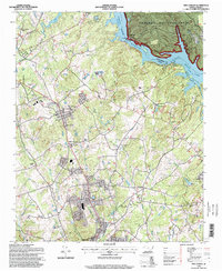
1994 Map of New London
USGS Topo · Published 1998About this map
Tuckertown Reservoir and the Yadkin River form a prominent corridor along the northern boundary of this Stanly County landscape. The area is defined by its transition from the wooded heights of the Uwharrie National Forest to the industrial and agricultural centers of New London and Badin. Transportation infrastructure is a central theme, evidenced by the Winston-Salem Southbound railroad line and the concentrated activity at Halls Ferry Jct. Local community life is mapped through an extensive network of rural landmarks, including Parkers Grove Ch, Bethel Church, and the Stanly County Airport. The presence of the Tuckertown Dam and Powerplant underscores the region's reliance on river-based energy, while smaller settlements like Palestine and Isenhour dot the inland terrain between major water bodies.
Find a feature on this map
47 named features on this map. Tap any name to fly to it.
Don’t see what you’re looking for? This feature index may not catch every label — zoom into the map to look around manually.
Map Details
Editions of this 1994 New London Map
This is the sole edition of this map. No revisions or reprints were ever made.
Other maps of this area

1949 · High Rock
USGS Topo · 1:24,000

1953 · Charlotte
USGS Topo · 1:250,000

1954 · Charlotte
USGS Topo · 1:250,000

1957 · Mount Pleasant
USGS Topo · 1:62,500

1957 · Albemarle
USGS Topo · 1:62,500

1957 · Denton
USGS Topo · 1:62,500

1960 · Charlotte
USGS Topo · 1:250,000

1962 · Charlotte
USGS Topo · 1:250,000
1962 · Gold Hill
USGS Topo · 1:24,000
1977 · High Rock
USGS Topo · 1:24,000