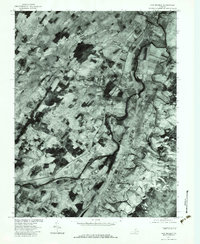
1977 Map of New Market
USGS Topo · Published 1983About this map
The North Fork Shenandoah River winds through this section of the valley, shaping the agricultural patterns and settlement locations during the late 1970s. This orthophotograph, prepared by the Geological Survey in cooperation with the Soil Conservation Service, reveals a landscape defined by expansive farm plots and small rural clusters. The town of New Market anchors the southern portion of the sheet, while Mt Jackson occupies the northeast corner, both positioned along the primary transit corridor. Between these centers, smaller communities like Quicksburg and Forestville maintain their distinct identities amidst the patchwork of fields. Numerous watercourses including Smith Creek and Holmans Creek feed into the main river branch, illustrating the drainage network that supported the region's long-standing milling and farming economy, evidenced by local names such as Plains Mill.
Find a feature on this map
12 named features on this map. Tap any name to fly to it.
Don’t see what you’re looking for? This feature index may not catch every label — zoom into the map to look around manually.
Map Details
Editions of this 1977 New Market Map
This is the sole edition of this map. No revisions or reprints were ever made.
Other maps of this area

1892 · Woodstock
USGS Topo · 1:125,000

1921 · Orkney Springs
USGS Topo · 1:48,000

1923 · Orkney Springs
USGS Topo · 1:62,500

1923 · Edinburg
USGS Topo · 1:62,500

1940 · Orkney Springs
USGS Topo · 1:48,000

1942 · Mt Jackson
USGS Topo · 1:62,500

1943 · Orkney Springs
USGS Topo · 1:62,500

1944 · Orkney Springs
USGS Topo · 1:62,500

1946 · Mt Jackson
USGS Topo · 1:62,500

1947 · Mt Jackson
USGS Topo · 1:62,500