
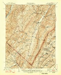
1943 Map of Orkney Springs
USGS Topo · Published 1943About this map
North Mountain and Shenandoah Mountain dominate this landscape along the border of West Virginia and Virginia, where early twentieth-century life centered on remote valley settlements and gaps. The map captures the tight-knit network of mountain schools and churches, such as Jenkins Chapel and Bowman School, that served families in the Lost River and Culler Run watersheds. A notable concentration of community landmarks appears around Mathias and Lost City, while the resort culture of the era is evident at Orkney Springs in Virginia. For genealogists and local historians, the sheet is particularly valuable for its documentation of family-named features like Tusing Cem and Halterman Hollow, alongside industrial curiosities such as the Saltpeter site. The terrain dictates a pattern of isolated farms and mountain gaps, including Bull Gap and Dellinger Gap, which historically facilitated movement between these steep ridges.
Find a feature on this map
97 named features on this map. Tap any name to fly to it.
Don’t see what you’re looking for? This feature index may not catch every label — zoom into the map to look around manually.
Map Details
Editions of this 1943 Orkney Springs Map
2 editions found
Other maps of this area

1891 · Romney
USGS Topo · 1:125,000

1892 · Franklin
USGS Topo · 1:125,000

1892 · Woodstock
USGS Topo · 1:125,000

1895 · Piedmont
USGS Topo · 1:125,000

1896 · Franklin
USGS Topo · 1:125,000

1920 · Petersburg
USGS Topo · 1:48,000

1920 · Moorefield
USGS Topo · 1:62,500

1921 · Orkney Springs
USGS Topo · 1:48,000

1921 · Petersburg
USGS Topo · 1:48,000

1921 · Greenland Gap
USGS Topo · 1:62,500