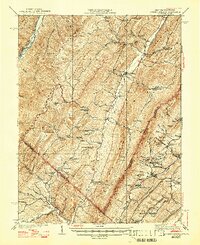
1943 Map of Orkney Springs
USGS Topo · Published 1947About this map
Orkney Springs sits at the foot of the Great North Mountain ridgeline, marking a landscape defined by the parallel ridges of the Appalachians during the 1940s. The map illustrates the rural infrastructure of Hardy County and Rockingham County, where narrow valleys are filled with a dense network of one-room schoolhouses like Snyder Springs School, Shoemaker School, and Bergton School. The presence of the Lumber RR along the South Fork South Branch Potomac River in the northwest corner highlights the timber industry's reach into these highlands.
Find a feature on this map
87 named features on this map. Tap any name to fly to it.
Don’t see what you’re looking for? This feature index may not catch every label — zoom into the map to look around manually.
Map Details
Editions of this 1943 Orkney Springs Map
2 editions found
Other maps of this area

1891 · Romney
USGS Topo · 1:125,000

1892 · Franklin
USGS Topo · 1:125,000

1892 · Woodstock
USGS Topo · 1:125,000

1895 · Piedmont
USGS Topo · 1:125,000

1896 · Franklin
USGS Topo · 1:125,000

1920 · Petersburg
USGS Topo · 1:48,000

1920 · Moorefield
USGS Topo · 1:62,500

1921 · Orkney Springs
USGS Topo · 1:48,000

1921 · Petersburg
USGS Topo · 1:48,000

1921 · Greenland Gap
USGS Topo · 1:62,500