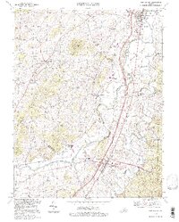
1994 Map of New Market
USGS Topo · Published 1997About this map
The North Fork Shenandoah River carves a winding path through the heart of the Shenandoah Valley, defining the rural character of this region. Notable for its deep agricultural roots and historic significance, the area around New Market and Mt Jackson is anchored by landmarks like the New Market Battlefield and the iconic Covered Bridge at Meems Bottom. The landscape is a mix of small settlements and educational institutions, including the Shenandoah Valley Academy and the Triplett Inst.
Find a feature on this map
56 named features on this map. Tap any name to fly to it.
Don’t see what you’re looking for? This feature index may not catch every label — zoom into the map to look around manually.
Map Details
Editions of this 1994 New Market Map
This is the sole edition of this map. No revisions or reprints were ever made.
Other maps of this area

1892 · Woodstock
USGS Topo · 1:125,000

1921 · Orkney Springs
USGS Topo · 1:48,000

1923 · Orkney Springs
USGS Topo · 1:62,500

1923 · Edinburg
USGS Topo · 1:62,500

1940 · Orkney Springs
USGS Topo · 1:48,000

1942 · Mt Jackson
USGS Topo · 1:62,500

1943 · Orkney Springs
USGS Topo · 1:62,500

1944 · Orkney Springs
USGS Topo · 1:62,500

1946 · Mt Jackson
USGS Topo · 1:62,500

1947 · Mt Jackson
USGS Topo · 1:62,500