
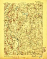
1893 Map of New Milford
USGS Topo · Published 1893About this map
New Milford serves as a primary hub within this late nineteenth-century landscape, situated where the Housatonic River meets the Still River. The industrial and transport patterns of the era are clearly defined by the Housatonic Railroad, which tracks the river's path and connects local depots such as Merwinsville and Gaylordsville. The map captures a transition in Western Connecticut's economy, showing established villages like Washington Green and Bridgewater alongside early rail-dependent developments like Washington Station and Roxbury Station.
Find a feature on this map
111 named features on this map. Tap any name to fly to it.
Don’t see what you’re looking for? This feature index may not catch every label — zoom into the map to look around manually.
Map Details
Editions of this 1893 New Milford Map
2 editions found
Other maps of this area

1889 · Derby
USGS Topo · 1:62,500

1891 · Derby
USGS Topo · 1:62,500

1892 · Winsted
USGS Topo · 1:62,500

1892 · Danbury
USGS Topo · 1:62,500

1892 · Cornwall
USGS Topo · 1:62,500

1892 · New Milford
USGS Topo · 1:62,500

1892 · Carmel
USGS Topo · 1:62,500

1893 · Carmel
USGS Topo · 1:62,500

1893 · Waterbury
USGS Topo · 1:62,500

1893 · Cornwall
USGS Topo · 1:62,500