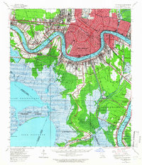
1950 Map of New Orleans
USGS Topo · Published 1966About this map
The Mississippi River defines the landscape of this mid-century survey, snaking through New Orleans and its surrounding parishes. The map reveals the intricate water management and transportation systems of the era, from the heavy industrial infrastructure of the Inner Harbor Navigation Canal and Harvey Canal to the sprawling rail networks of the Illinois Central and Southern Pacific. Urban density in the city core contrasts sharply with the wetlands of Jefferson and St. Charles Parishes, where the Line of Demarcation Between Salt Marsh and Fresh Marsh is noted.
Find a feature on this map
100 named features on this map. Tap any name to fly to it.
Don’t see what you’re looking for? This feature index may not catch every label — zoom into the map to look around manually.
Map Details
Editions of this 1950 New Orleans Map
This is the sole edition of this map. No revisions or reprints were ever made.
Other maps of this area

1891 · Hahnville
USGS Topo · 1:62,500

1891 · Spanish Fort
USGS Topo · 1:62,500

1891 · Pointe a La Hache
USGS Topo · 1:62,500

1891 · New Orleans
USGS Topo · 1:62,500

1892 · Barataria
USGS Topo · 1:62,500

1892 · Chef Menteur
USGS Topo · 1:62,500

1892 · Bonnet Carre
USGS Topo · 1:62,500

1892 · Cut-Off
USGS Topo · 1:62,500

1892 · St. Bernard
USGS Topo · 1:62,500

1892 · Pointe a La Hache
USGS Topo · 1:62,500