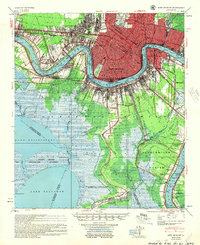
1954 Map of New Orleans
USGS Topo · Published 1955About this map
The Mississippi River defines the geography of this mid-century survey, snaking through a landscape of heavy industry, established neighborhoods, and expanding infrastructure. Large-scale river features like Carrollton Bend and Gouldsboro Bend are flanked by critical logistics hubs, including the Public Cotton Warehouse and the Foreign Trade Zone. Beyond the urban core of New Orleans, the map details the suburban growth in Metairie Terrace and the industrial corridors of the West Bank near Harvey and Gretna.
Find a feature on this map
104 named features on this map. Tap any name to fly to it.
Don’t see what you’re looking for? This feature index may not catch every label — zoom into the map to look around manually.
Map Details
Editions of this 1954 New Orleans Map
This is the sole edition of this map. No revisions or reprints were ever made.
Other maps of this area

1891 · Hahnville
USGS Topo · 1:62,500

1891 · Spanish Fort
USGS Topo · 1:62,500

1891 · Pointe a La Hache
USGS Topo · 1:62,500

1891 · New Orleans
USGS Topo · 1:62,500

1892 · Barataria
USGS Topo · 1:62,500

1892 · Chef Menteur
USGS Topo · 1:62,500

1892 · Bonnet Carre
USGS Topo · 1:62,500

1892 · Cut-Off
USGS Topo · 1:62,500

1892 · St. Bernard
USGS Topo · 1:62,500

1892 · Pointe a La Hache
USGS Topo · 1:62,500