
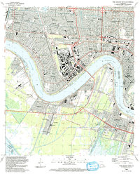
1992 Map of New Orleans West
USGS Topo · Published 1992This historical map portrays the area of New Orleans West in 1992, primarily covering Jefferson Parish as well as portions of Orleans Parish and St. Charles Parish. Featuring a scale of 1:24000, this map provides a highly detailed snapshot of the terrain, roads, buildings, counties, and historical landmarks in the New Orleans West region at the time. Published in 1992, it is one of 2 known editions of this map due to revisions or reprints.
Find a feature on this map
86 named features on this map. Tap any name to fly to it.
Don’t see what you’re looking for? This feature index may not catch every label — zoom into the map to look around manually.
Map Details
Editions of this 1992 New Orleans West Map
2 editions found
Historical Maps of Oak Ridge Park Through Time
30 maps found

1891 Spanish Fort
Jefferson Parish, LA

1932 New Orleans NW
Jefferson Parish, LA

1932 New Orleans SE
Jefferson Parish, LA

1932 Sabine Pass NE
Jefferson Parish, LA

1936 Spanish Fort
Jefferson Parish, LA

1938 Indian Beach
Jefferson Parish, LA

1938 New Orleans West
Jefferson Parish, LA

1939 Lorman
Jefferson Parish, LA

1940 Bertrandville
Jefferson Parish, LA

1946 Sabine Pass NE
Jefferson Parish, LA

1947 Bertrandville
Jefferson Parish, LA

1949 Barataria Pass
Jefferson Parish, LA

1951 Bertrandville
Jefferson Parish, LA

1951 New Orleans West
Jefferson Parish, LA

1952 Indian Beach
Jefferson Parish, LA

1953 Spanish Fort
Jefferson Parish, LA

1965 Indian Beach
Jefferson Parish, LA

1965 New Orleans West
Jefferson Parish, LA

1966 Bertrandville
Jefferson Parish, LA

1967 Spanish Fort
Jefferson Parish, LA

1973 Barataria Pass
Jefferson Parish, LA

1973 Three Bayou Bay
Jefferson Parish, LA

1992 Bertrandville
Jefferson Parish, LA

1992 Indian Beach
Jefferson Parish, LA
1992 New Orleans West
Jefferson Parish, LA

1993 Barataria Pass
Jefferson Parish, LA

1995 Bertrandville
Jefferson Parish, LA

1998 Indian Beach
Jefferson Parish, LA

1998 New Orleans West
Jefferson Parish, LA

1998 Three Bayou Bay
Jefferson Parish, LA