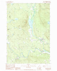
1989 Map of New Portland
USGS Topo · Published 1989About this map
New Portland and its surrounding hamlets of North New Portland and East New Portland sit at the confluence of several significant waterways in Somerset County. The landscape is defined by the winding course of the Carrabassett River and the steady flow of Gilman Stream, which drains the prominent Gilman Pond to the north. These valleys are hemmed in by steep elevations like Gilman Pond Mtn and Hackett Hill, creating a topographical arrangement where settlements cling to the narrow riverbanks and lower slopes. The presence of several Cem markers and the Hogan Landing Strip provides specific points of interest for genealogists and local historians tracking 20th-century land use. The map illustrates a transition between the more developed village centers and the dense woods of Lexington and Kingfield, showing a network of roads that follow the natural contours of Lemon Stream and Newell Brook.
Find a feature on this map
41 named features on this map. Tap any name to fly to it.
Don’t see what you’re looking for? This feature index may not catch every label — zoom into the map to look around manually.
Map Details
Editions of this 1989 New Portland Map
This is the sole edition of this map. No revisions or reprints were ever made.
Other maps of this area

1903 · Bingham
USGS Topo · 1:62,500

1904 · Anson
USGS Topo · 1:62,500

1905 · Bingham
USGS Topo · 1:62,500

1928 · Dead River
USGS Topo · 1:62,500

1930 · Kingfield
USGS Topo · 1:48,000

1931 · Dead River
USGS Topo · 1:48,000

1932 · Kingfield
USGS Topo · 1:62,500

1944 · Dead River
USGS Topo · 1:62,500

1948 · Bangor
USGS Topo · 1:250,000

1949 · Jackman
USGS Topo · 1:250,000