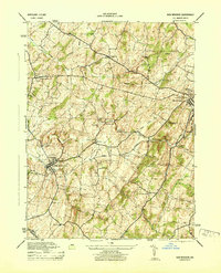
1944 Map of New Windsor
USGS Topo · Published 1944About this map
Western Maryland rail lines cut through the heart of Carroll County in the mid-1940s, connecting agricultural hubs like New Windsor and Westminster with the broader region. The landscape is defined by the prominent Wakefield Valley and the rising elevations of Parrs Ridge, where small farming communities such as Frizzelburg, Uniontown, and Medford are situated. Water-powered industry remains visible through sites like Roop Mill, which includes a labeled Roop Mill Flume, Wagners Mill, and Wakefield Mill along the banks of Little Pipe Creek. Higher education is a notable presence, with the grounds of New Windsor College and Western Maryland College both established in their respective towns. Other local landmarks, such as the John Hyde Quarry and the Westminster Sewage Plant, reflect the industrial and civic infrastructure supporting the county at this time.
Find a feature on this map
39 named features on this map. Tap any name to fly to it.
Don’t see what you’re looking for? This feature index may not catch every label — zoom into the map to look around manually.
Map Details
Editions of this 1944 New Windsor Map
2 editions found

Other maps of this area

1892 · Ellicott
USGS Topo · 1:62,500

1893 · Frederick
USGS Topo · 1:125,000

1894 · Ellicott
USGS Topo · 1:62,500

1894 · Frederick
USGS Topo · 1:125,000

1905 · Westminster
USGS Topo · 1:62,500

1906 · Ellicott
USGS Topo · 1:62,500

1908 · Patapsco
USGS Topo · 1:125,000

1909 · Mount Airy
USGS Topo · 1:62,500

1911 · Taneytown
USGS Topo · 1:62,500

1942 · Gettysburg
USGS Topo · 1:125,000