
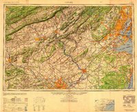
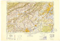
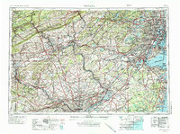
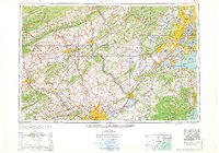
1949 Map of Newark
USGS Topo · Published 1949This historical map portrays the area of Newark in 1949, primarily covering Essex County as well as portions of Essex County, New York, and Pennsylvania. Featuring a scale of 1:250000, this map provides a highly detailed snapshot of the terrain, roads, buildings, counties, and historical landmarks in the Newark region at the time. Published in 1949, it is one of 3 known editions of this map due to revisions or reprints.
Map Details
Date Portrayed1949
Date Published1949
PublisherU.S. Geological Survey
Map TypeTopographic
Scale1:250000
Physical Dimensions29 x 23.7 inches
Editions of this 1949 Newark Map
3 editions found

Historical Maps of Newark Through Time
8 maps found


Featured Locations
- Newark, NJ
- Bergen County, NJ
- Berks County, PA
- Bucks County, PA
- Burlington County, NJ
- Carbon County, PA
- Chester County, PA
- Delaware County, NY
- Delaware County, PA
- Essex County, NJ
- Essex County, NY
- Hudson County, NJ
- Hunterdon County, NJ
- Kings County, NY
- Lancaster County, PA
- Lehigh County, PA
- Luzerne County, PA
- Mercer County, NJ
- Mercer County, PA
- Middlesex County, NJ
- Monmouth County, NJ
- Monroe County, NY
- Monroe County, PA
- Montgomery County, NY
- Montgomery County, PA
- Morris County, NJ
- New York County, NY
- Northampton County, PA
- Ocean County, NJ
- Passaic County, NJ
- Philadelphia County, PA
- Queens County, NY
- Richmond County, NY
- Schuylkill County, PA
- Somerset County, NJ
- Somerset County, PA
- Sussex County, NJ
- Union County, NJ
- Union County, PA
- Warren County, NJ
- Warren County, NY
- Warren County, PA
- New Jersey
- New York
- Pennsylvania
Source Details
SourceU.S. Geological Survey
CopyrightPublic Domain