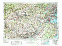
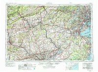
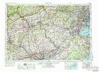
1944 Map of Newark
USGS Topo · Published 1986About this map
Industrial hubs and transportation corridors dominate the landscape from Newark to Philadelphia, reflecting the region's mid-century economic reach. This survey highlights the complex rail networks of the Pennsylvania Railroad, Reading Railroad, and Lehigh Valley Railroad that connected the anthracite coal regions of Hazleton and the steel mills of Bethlehem with the ports of the New York Bay. Along the Delaware River, the transition from the steep ridges of Blue Mountain to the rolling terrain near Trenton is clearly defined, showing the strategic placement of early settlements and the subsequent growth of suburban centers like Levittown.
Find a feature on this map
269 named features on this map. Tap any name to fly to it.
Don’t see what you’re looking for? This feature index may not catch every label — zoom into the map to look around manually.
Map Details
Editions of this 1944 Newark Map
5 editions found


Other maps of this area

1884 · Whitings
USGS Topo · 1:62,500

1888 · Franklin
USGS Topo · 1:62,500

1888 · Plainfield
USGS Topo · 1:62,500

1888 · Bordentown
USGS Topo · 1:62,500

1888 · Pemberton
USGS Topo · 1:62,500

1888 · Barnegat
USGS Topo · 1:62,500

1888 · Morristown
USGS Topo · 1:62,500

1888 · Hackettstown
USGS Topo · 1:62,500

1888 · New Brunswick
USGS Topo · 1:62,500

1888 · Mount Holly
USGS Topo · 1:62,500