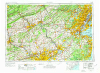
1944 Map of Newark
USGS Topo · Published 1974About this map
The Newark and Philadelphia metropolitan corridors dominate this mid-century landscape, connected by the burgeoning New Jersey Turnpike and a dense network of transit lines. The map reveals an era where the Pennsylvania Railroad and Lehigh Valley Railroad still served as vital arteries through the industrial heartlands of Allentown, Bethlehem, and Reading. Beyond the urban centers, the terrain rises into the Pocono Mountains and Kittatinny Mountain, while the shorelines of Staten Island and Sandy Hook remain prominent coastal landmarks.
Find a feature on this map
442 named features on this map. Tap any name to fly to it.
Don’t see what you’re looking for? This feature index may not catch every label — zoom into the map to look around manually.
Map Details
Editions of this 1944 Newark Map
5 editions found

Other maps of this area

1884 · Whitings
USGS Topo · 1:62,500

1888 · Franklin
USGS Topo · 1:62,500

1888 · Plainfield
USGS Topo · 1:62,500

1888 · Bordentown
USGS Topo · 1:62,500

1888 · Pemberton
USGS Topo · 1:62,500

1888 · Barnegat
USGS Topo · 1:62,500

1888 · Morristown
USGS Topo · 1:62,500

1888 · Hackettstown
USGS Topo · 1:62,500

1888 · New Brunswick
USGS Topo · 1:62,500

1888 · Mount Holly
USGS Topo · 1:62,500