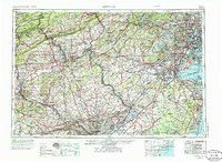
1944 Map of Newark
USGS Topo · Published 1986About this map
The Delaware River serves as the central artery for this mid-20th-century corridor, connecting the industrial hubs of Philadelphia, Trenton, and Easton. This survey captures a region in transition, where the established rail networks of the Pennsylvania Railroad and Reading Railroad are supplemented by the emerging dominance of the New Jersey Turnpike and the Garden State Parkway. The presence of Levittown and Lakewood signifies the rapid suburbanization pushing outward from the core cities into former farmland.
Find a feature on this map
207 named features on this map. Tap any name to fly to it.
Don’t see what you’re looking for? This feature index may not catch every label — zoom into the map to look around manually.
Map Details
Editions of this 1944 Newark Map
5 editions found

Other maps of this area

1884 · Whitings
USGS Topo · 1:62,500

1888 · Franklin
USGS Topo · 1:62,500

1888 · Plainfield
USGS Topo · 1:62,500

1888 · Bordentown
USGS Topo · 1:62,500

1888 · Pemberton
USGS Topo · 1:62,500

1888 · Barnegat
USGS Topo · 1:62,500

1888 · Morristown
USGS Topo · 1:62,500

1888 · Hackettstown
USGS Topo · 1:62,500

1888 · New Brunswick
USGS Topo · 1:62,500

1888 · Mount Holly
USGS Topo · 1:62,500